Sunday, May 31, 2009

You know you want to...

We drove out to DM today, and so the Tikit was in the back of the Prius. I didn't have to pack it as tightly as I did last weekend, so it looks pretty relaxed in the trunk, and I though to take some pictures.


Of course, the Tikit was just sitting there eyeing me coyly, as if to say "you know you want to go for a ride, big boy." What was I going to do? So I took it out and rode it up to Fort Bowie. I ran into a ranger up there, who though the Tikit was pretty cool, and we talked about National Parks we had in common for a while. The decent from Fort Bowie is very steep at first, but it levels out a bit and becomes very nice. Of course it's very, very short - it's probably a mile from the trailer to the fort. But it was a nice ride. My iPhone ran out of juice, so I couldn't take any pictures. Guess I'll have to go up again...

2 miles, 30 minutes, including yakking.

Yesterday I went for a ride down Aviation Highway, south on Alvernon (next time I'll take Palo Verde) and back across on Ajo and back up on Park. It was a pretty nice ten-mile ride - enough to get my metabolism up, but not demanding, so I could do it every day. I went that way kind of randomly, so I didn't actually plan the route, and missed out on a couple of great opportunities for bike paths. The route under I-10 there is not particularly great, although there was almost no traffic on Ajo, so it was fine. But it turns out that there's a drainage channel that runs all through that area, and there's a bike path along and in some cases *in* the drainage channel, so that you can completely bypass all that stuff. It looks pretty cool - I will try it next time.

11 miles, less then an hour.

Friday, May 29, 2009

My favorite ride?

I went up Gates Pass. Again. Today it was partly cloudy, and the clouds were in the west, so I left well before sunset and did most of the ride in sunlight. I did get zapped for about fifteen minutes when the clouds broke briefly, but mostly it worked out. The big plus to going so early is that it's much, much prettier.


This is looking east along Kinney from the first place I stopped in the park, maybe a mile up the road from the Drexel Fire District fire station and the Circle K there.


You see these cacti all over the place at certain elevations. They're completely nonexistent out at Diamond Mountain, and also in Tucson proper, but go maybe 100 feet uphill or ten miles south and suddenly they're everywhere. From the car window they look fuzzy and cuddly, but once you get closer to them you realize that they are a little too clingy to be the easiest of friends.


This is shot toward the sunset from the same rest stop.


This is a long shot of Gates Pass from the intersection of Gates Pass Road and Kinney Road. It's always chancy to identify mountains and passes from a distance, but I'm pretty sure the pass is in fact the low point you see among the peaks.


This is shot down the road a piece from the intersection of Gates Pass Road and Kinney Road. The sun was just beginning to cross the horizon, and this is kind of the classic "Sunset from Gates Pass" image, with the saguaro on the left with fruit on it.


This is from the same location, looking up the road instead of down.


If you look at a map of Gates Pass Road, you'll see two major switchbacks - one is the pass itself, and the other is about a quarter mile below the pass, where the climbing gets really intense. I stopped there to get another sunset shot, and also took this shot looking back at the mountain in Tucson Mountain Park (I assume it's called Tucson Mountain, but don't know that for a fact).


This is looking up toward the pass at the mountain to the left of the pass. A very typical Arizona mountain view.


And here's what the sunset looked like from there. The sun is all the way behind a sharp peak off on the horizon, but it's still very bright.


Here I'm just below the pass at pretty much the last safe pullout, taking one last picture of the valley. What you're seeing off in the distance is first Tucson Mountain County Park, and then some mostly undeveloped land, and off in the distance the Tohono O'Odam reservation.


And here is the obligatory shot up at the very last of the climb to gates pass. The camera is level here - this isn't exaggerated either by camera tricks or simply by perspective.

25.4 miles round trip, and around two hours, but I don't really know. And yes, this does seem to be my favorite ride in Tucson at the moment. But it felt pretty easy this time, so who knows how long that will last - I may have to add in the McCain loop soon. By the way, if you click on the pictures you get bigger versions...

Friday, May 22, 2009

A change of pace: Mission San Xavier del Bac

I'm a little bored with Gates Pass for the moment, so last night I decided to try a run down to Mission San Xavier del Bac and back. This is about a third of the famous Shootout ride, and in fact reading about the Shootout is what gave me the idea.

The bad news is that the mission is really not very far out of town, so most of the ride is in town, just getting there. I decided to do a straight shot down Mission Boulevard, which goes almost all the way down to the mission. I can't say much good about the in-town part of this ride - the shoulder is striped, but narrow, probably no more than 18" wide the whole way. It seemed relatively clean. Traffic was heavy, but not chaotic.

The last three miles are in the Tohono O'Odham nation, and I was a little concerned about that part of the ride because apparently there is a bit of bad blood between some local residents and the riders of the Shootout. But for whatever reason, as I crossed the border into Tohono O'Odham land, I felt kind of like I was coming home - maybe it reminded me a bit of the farm in Oklahoma, I don't know.

The road there is really narrow, and has a lot of traffic, but for whatever reason I felt fairly comfortable riding there - all the cars gave me a wide berth, and the traffic thinned out the farther south I got. Still, this is not an ideal route, and you can cut east and take neighborhood streets at least for the first two miles, so that might be prudent, and I will try it next time I do this ride. Of course, if you're going for speed and distance, you probably want to stay on Mission and just be careful.

The road to the mission takes you to a little town center there, with lots of speed bumps. I saw quite a few big mastiffs, but none of them approached me. The mission is a lovely and unusual structure, which I've seen from a distance many times, but never from up close.

The little community that surrounds the mission is quite small, and it was behind me very quickly as I followed San Xavier road towards I-19. The road crosses an arroyo and arrows through some rural farmland before reaching the highway. This section of the road is quite pretty, in a very Sonoran-desert way. There's one section where the road crosses a low spot and all you can see around you, other than a few houses a half mile ahead, are cacti and scrub.

The road continues into south Tucson, where it turns into Sixth Avenue as it crosses Los Reales. Sixth Avenue wasn't bad at first, but got progressively worse as I went further north toward the intersection with Nogales Highway. It may be better to cut west at Los Reales and head north on 12th to Bilby, then cut east again and head north on Liberty. On the plus side, heading north on Sixth was fast - I was pretty much keeping up with traffic, and got home very quickly. Then Andrea and I ate spaghetti and mainlined the Trueblood disc we had gotten in the mail from Netflix that morning...

Total distance: 20 miles. Time: about 1:45 (guessing). I had to fight a headwind on the way down - that's my excuse...

Thursday, May 21, 2009

In the improved coffee karma department...

...it turns out that there is now a place in Tucson where you can get genuinely exquisite coffee. There's this guy with a trailer that's outfitted as a coffee brewing station. Hey, it's Tucson! Much of the best food in Tucson is served out of trailers, or so I suspect. I passed a tamale trailer on the way to Gates Pass the other day that looked like the place to be; I almost stopped, but chickened out. Maybe next time. But I digress.

The owner, Jason, calls his business Cafe VanGo - a suitably Tucsonan riff on a popular cafe naming scheme. The setup is basically just the trailer and a couple of tables under a shaded awning out in the parking lot; despite the theoretical lack of atmosphere, it kind of works, or maybe it's just that the coffee is so good that you see flowers blooming in your peripheral vision.

Because the coffee really is that good. It's at least as good as the coffee I was getting when I was in Austin at Caffe Medici; possibly better. It's as good as the coffee at Everyman Espresso in New York. I don't know of a place that has coffee that good in the Bay Area. I asked for a macchiato, and after a brief secret handshake to indicate that I knew what I was asking for, got a cup of about an ounce and a half of the most exquisite coffee drink known to humankind.

Andrea encouraged me to order a second shot, so I had a breve macchiato, which was even better. He really makes a purist macchiato - the shot was short, and there was just enough milk to mark the coffee - not much weaker than straight espresso. The espresso was bright and citrusy and chocolaty. Bring your own cup if you don't want paper. That's the only thing I could even remotely complain about, and it's not a serious complaint, because I'm happy to bring my own cup, and I will next time.

Oh, one nice thing about Jason was that despite the fact that he won the 2008 Southwest Regional Barista Competition, and despite the fact that he's got an encyclopedic knowledge of coffee, he didn't seem to bring an ounce of attitude to his work. He was very apologetic about asking me if I knew what a macchiato was. He didn't try to tell me what I wanted. He just tried to figure out what I wanted, and then made it, perfectly.

So if you are in Tucson, and love coffee, I really recommend checking out Cafe VanGo. If you're driving through on the highway, make the detour. Bear in mind that he's only open until 3 in the afternoon, though.

BTW, he also has a Clover. I might check that out at some point, just to see how it does.

Oh, there's a good shot of the trailer here: Tucson Foodie Blog: Cafe VanGo

Wednesday, May 20, 2009

Another try at Gates Pass...

I went up Gates Pass again last night. My Saturday night ride over the pass took a lot out of me, so this time I decided to use an electrolyte supplement. Back when I was riding in the Bay Area, I used to use a really yummy sweetened sports drink mix when I rode, and it worked pretty well, but I wanted to see how much difference the sugars made in the ride, and so this time I just used a straight mineral supplement called Endurolytes powder, by a company called Hammer Nutrition.

To be honest, these supplements kind of give me the creeps. What can I say, I'm a natural food junkie and I'm not a bike racer. I don't go as fast as they do. So it seems unfair that I have to use this extra stuff. I was poking around the other night and discovered that there's a regular ride on Tuesday mornings that follows the same route I do, except they add an extra six miles by going around the McCain loop in Saguaro National Park. And they do the ride in under two hours. So of course *they* need sports drinks, but a mere mortal like me ought to be able to do without. Apparently no such luck.

The Endurolyte powder is advertised as "tasteless," which I guess means unflavored. It tasted like drinking rock flour - kind of earthy and powdery, and the water with it mixed in wasn't refreshing the way plain water is. So there is a certain yuck factor, but it seemed to help - I didn't have the same reaction last night that I did on Saturday night. However, I was ravenously hungry, and still wound up with a headache. So I think I actually need the drink with the carbs built in. Sigh.

I took Irvington instead of Ajo this time, and I liked it better. Irvington still has a lot of traffic but it's a lot less than Ajo, and the shoulder is a lot cleaner. Also, the slope seems less sculpted, so although it's uphill all the way, mostly it's such an easy uphill it might as well be flat, and then there are a few discrete climbs that are relatively short, and a bit steeper, so you can just power through them. However, the route I took *to* Irvington wasn't so great. I tried to take Bike Route 3 down to Michigan street, and then cut across there to the other side of I-19 and take the bike path down to Irvington.

This doesn't work very well. First, all the major crossings on this route are uncontrolled, so you are crossing four lanes of traffic that doesn't stop. Traffic was light, so this was not an inconvenience, but I think I will try just coming down Mission next time.

The next problem is that the I-19 crossing is a pedestrian bridge, not a bike bridge, so you have to dismount and walk. There was broken glass all over the bridge, and it looks like a place where people routinely get drunk and party. Call me a wimp, but I don't feel like riding a gauntlet of drunk people - they tend to have low impulse control, and somebody dressed in cycling clothes is an obvious target for "a little fun." There's no escape path once you're on the bridge, and it's pretty narrow, so even two people could hem you in pretty effectively. There was nobody on the bridge in this case, though.

The path along the Santa Cruz River to Irvington is nice. Last night's storm hit as I was heading south on it, though, and that was interesting. A really strong headwind, with giant raindrops, and dust blowing from the developments down on Calle Santa Cruz like clouds of dense fog. And there's no easy transition from the path to Irvington, possibly because there's no protected crossing of the Santa Cruz river there. Another reason to take Mission, which is on the far side of both the river and I-19. The crossing at Congress Street is much nicer.

Anyway, aside from these obstacles it was a nice ride. Because of the storm I was able to leave a little earlier, so I got to the park when it was still light enough to take a picture, as you can see above. Desert storms make for pretty sunsets. Despite the heavy rain on the Santa Cruz River, I never got wet enough to be bothered.

Total distance: 27.3 miles, because I added Irvington but didn't have to detour south to 18th this time. Total time was about two hours again.

Sunday, May 17, 2009

Night Ride up Gates Pass

I wasn't going to do it before I scoped it out a bit, but it looked so good on the map. I had to try it. So I did Gates Pass tonight. I left before the sun set, because I had decided to go up Ajo Highway, and I wanted some light for that. This turned out to be a good choice, although I think next time I do this ride I will detour south to Irvington and see if that's any better.

The stretch of Ajo Highway from La Cholla, where I got on, almost all the way to Kinney, is a fast two-lane road with a wide striped paved shoulder (eight feet wide). There's a lot of traffic, and the wind blows straight down the road (at least, it did this time, and I suspect it does a lot, because there is a pass at the top to channel it), so the air quality isn't very good, and while the shoulder is wide, it's also got a lot of broken glass and other schmutz on it.

I think this would be a really nice early morning ride, before the traffic picks up, but with the rush out of town, my theory is that Irvington will be more fun. Of course, I haven't tried it yet, so I may have to eat my words. The ascent is at an angle that would be perfectly pleasant if it weren't for all the traffic - you gain a hundred or two feet of elevation from La Cholla to Kinney, but that's over a couple of miles.

Once I turned off on Kinney, the traffic slacked off quite a bit, and there's a nice wide bike lane without a lot of crap in it. It's still not a particularly wonderful biking road, but there's nothing wrong with it - it'll get you where you're going. At some point you pass through a little wide spot in the road with a Family Dollar store and a fire station, and then shortly after that the road turns into what must be a National Park Service road. No bike lane, but the pavement quality is great. By this time, traffic had slacked off to the point where I think maybe four or five cars passed me all the way from there to Gates Pass Road.

A little way in here I stopped off to answer a call of nature, and took the picture on the left. There are parking pullouts about every quarter mile along this stretch of road. Obviously there wasn't much light - I had to shoot this with the backup headlight, which is easy to remove. My only camera on this ride was the iPhone, so I didn't have a flash.

Then I turned off all my lights (taillight and both headlights) and stood there listening. My eyes adjusted pretty quickly, and I was able to see a variety of different cacti and trees, and hear what was either a pack of coyotes or else some kids yipping off in the distance. This section of the ride felt *very* remote, almost spookily so, even though I was only a few miles from town. It's kind of amazing to me that I can get to a ride like this just riding out our front door - I tend not to think of Saguaro N.P. as being a big deal, but suddenly it felt more that way.

Anyway, when I was done I lit everything back up and kept going - it was still about a mile to the intersection of Kinney and Gates Pass Road, and stopping had allowed my muscles to cool off, so it took me a while to get back into the swing of things. The ascent up to Gates Pass starts off with a couple of swooping washes, and then starts to trend more consistently up. It's a bit steeper than Ajo, so I really felt like I was working, but it still wasn't too bad. But I wasn't going very fast, so at one point I turned off the bright headlight and just rode with the safety light - it was enough to stay on the road, and the desert really opened up as my eyes adjusted. Unfortunately I didn't feel safe with the light off when there was oncoming traffic, so I turned it back on. Two trucks passed me from behind, which was a surprise - I'd had no traffic behind me for a while.

Then the road turned steep, and I started having to work. To put it in perspective, I don't think the ascent to the pass is more than about 300 feet from the intersection of Kinney and Gates Pass Road, but probably half of that is in the last quarter mile. Not a brutal ascent, but enough to finally drive me down to the lowest gear. You crest the pass kind of suddenly, without any fanfare - there's just a little hump, and then the exit from the scenic view area at the pass. Suddenly you can see Tucson again, way off in the distance.

I shot this picture using the bright headlight to light the road. If you look at the high resolution version you can see a bit of detail, but I don't have the ability to take a timed shot with the iPhone, so the image quality isn't very good. It's very pretty up there in real life. And the descent from the pass is sweet - it's not steep, but it's long. It's a brisk downhill from the summit all the way to Anklam Road - not fast enough that I felt nervous doing it at night, but fast enough that I only had to pedal in a few flat sections. I picked up a follower at one point who couldn't pass me for a while, but they seemed willing to be patient, and finally passed me when an opportunity came in a slower part of the descent.

I don't know how long the descent took - maybe five minutes - but it was pure bliss. Finally I got to Anklam Road and had to ascend a bit again. Unfortunately I'd cooled off from the descent, and so the ascent up Anklam was slow at first. But then once I'd crested the top of Anklam it was a nice mellow but speedy descent all the way to the Congress Street underpass at I-10, where I discovered I couldn't cross because it closed a little early for construction (it was supposed to close at 9:00, but I passed it around 8:50, I think).

There used to be a bicycle underpass at 18th street that was kind of narrow and grim. There's now a full-fledged underpass there, but it's not open for business yet because it's not paved, and there's too much traffic on the frontage road because of the freeway entrance and exit closures. But as it turns out, the dirt there is packed down hard enough that you can just ride over it safely. The trick is crossing the frontage road safely - the traffic is going over sixty miles an hour, which is faster than most crossings one is used to on a bicycle, so it would be easy to jump out without enough of a safety margin. That said, I crossed it with no difficulty, and rode home.

Total time, door to door, about two hours, about 26 miles. Tikit behaved admirably. Jury's out on the bottle cage - it's wandering a bit.

Bicycling in Tucson...

Andrea and I have been living in Tucson since summer of 2004. Our first summer in Tucson was mostly nice - Tucson is a bit of a ghost town in the summer, and so we got to watch a lot of tumbleweeds blow. Everybody has different ways of getting exercise; my two favorite ways turned out to work very badly in Tucson. I tried, really I did, but never got into the swing of either bicycling or rollerblading. As you can see from my (not so) recent posts, I've been trying to get back into bicycling, but the big question was whether I could keep up my bicycling in the summer.

Last Saturday I rode over to the Ordinary Bike Shop, which is a pretty cool bike shop in Tucson. What's cool about OBS is mostly that they have a good group of mechanics, and they know what they are talking about. And while they do not have a huge selection of bike stuff, what they have is really good. So I was able to get a really nice bicycle light there - it's a high intensity LED powered by a lithium-ion battery pack about the size of a D-cell. The beam is strong enough that I can safely ride at a good clip without overrunning my headlight. I can't bomb down a steep hill, but it works just fine for more conservative riding in the hills.

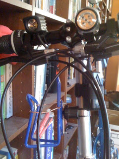
Looking at the picture, you can see a small light to the left, and a larger light to the right. The smaller light is the Nite Rider high intensity light. The other light looks like it ought to be more powerful, but it's actually quite wimpy, and badly built. I keep it installed because it's kind of dumb to go riding on a bicycle at night with no backup headlight. If your headlight fails for some reason, what do you do, call for rescue? Walk ten miles home? The crappy light isn't much use on streets with no street lights, but it'll get me home faster than walking, and it's fine as a safety light, so that people can see me.

You can also see a rather weirdly-installed bottle cage in the picture just below the Nite Rider headlight. The standard location for the bottle cage on the Tikit is on the seat post downtube, to the rear, as you can see in the bigger picture. This is necessary because the front of the downtube folds into the bundle, and there's no space for the cage.

Unfortunately, this is an extremely awkward place to have a bottle, at least on the large Tikit. I find that I have to concentrate pretty hard to get the bottle back in after I've taken a drink, so it seems like a safety concern to me. The second cage is in an awkward location too, but it works. I tried it out last night, and it was a lot easier to use, but because it's sideways, the bottle has a tendency to fall out when you go over a hard bump - I had to catch the bottle two or three times, once at a very awkward moment. So I modded the cage with a couple of bits of 20-amp wire. These appear to do the job of keeping the bottle from falling out of the cage, although the jury's out on that - I have yet to road-test this mod.

I've gone on four night rides so far. I'm going to tell you about them more for people who are interested in riding in Tucson than for the three people who regularly read this blog, so if you get bored, skip to the end.

The first two rides were fast, but short - ten miles, probably averaging 15mph, which is fast for me. We live in the flat part of Tucson, and one of the rides I've been doing involves going north on Mountain Boulevard to River Road, and then up into the hills, which pretty much start on the other side of River. But those hills are pretty steep, and I was a bit nervous about riding at night there, so I just rode *to* River, and then turned around and came back. But riding on the flats isn't all that much fun, plus Mountain is under construction, and there are loose dirt piles in the road that aren't fun to navigate in the dark even with a nice headlight.

So the third ride was just a grand tour - I rode down the Aviation Highway bikeway almost to the end, then cut across to Kolb on Stella. This was a pretty nice ride - the bike path is wide, there are only a few grade crossings, and Stella is pretty low traffic. I didn't push myself as hard, because I wanted to go twenty miles instead of ten, which probably made it more pleasant. I screwed up at Craycroft by failing to notice that the bike path moves from the north to the south side of Golf Links Road at that point, but traffic was very light, so I wound up crossing to the bike path after a half mile.

Unfortunately, I didn't remember the bike map very well at that point, and I discovered that Tucson's bike routes have somewhat spotty signage. So I wound up just riding north on Kolb to Broadway. The bike lane on Kolb is perfectly pleasant, and traffic on that stretch wasn't bad. However, on the other side of Broadway, the shoulder gets narrower for some reason, so I wound up cutting back to Broadway. The Tucson bicycle map shows the stretch of Broadway from Kolb east to Craycroft as being for hard-core bicyclists only, but I found it quite pleasant. The bike lane there is a shared lane - shared with the Tucson buses. But since the Tucson bus system doesn't run very much at night, I didn't have to share it with anyone. The lane was very wide, and the relatively frequent bus traffic in the day seems to keep it swept pretty clean. I don't know if it's as pleasant to ride during the day, but I had no complaints.

However, Broadway is a high traffic street, and despite the nice wide, clean bus lane, I wanted to get off of Broadway, so I cut north on Craycroft and found the Third Street Bikeway at Rosewood. Signage on the bikeway is very spotty, and I got lost several times. The worst was when the street I was on subtly curved through 90 degrees and I would up back on 5th Street. Not a big deal - if I rode this path more frequently I don't think I'd have any trouble - but it's worth memorizing the changes in the route before trying to follow it the first time if you are in a hurry.

The Third St. Bikeway took me back to the University, and then I cut south on Highland back to Broadway and took Broadway back to our neighborhood, for a total of about 20 miles in two hours. Slow, but pleasant.

One of the best parts of riding at night in Tucson is that you can just wear regular biking clothes and no sunblock - it's almost like biking in the northeast. One difference is that it's a lot hotter, although the later it gets, the cooler it gets. I was worried about hydration, but it seems as if a single 20-oz water bottle is enough for 20 miles. Wearing bicycle shorts and shirt, it's very comfortable, and I haven't felt overheated at all, even when really pushing it. The low humidity helps with that.

Last night I did a really fun ride - one I've been wanting to do for a while. I crossed I-10 at Congress, which isn't particularly fun, but is okay - traffic out of downtown at night isn't bad, and Tucsonans are pretty polite. Once across I-10, there was a nice striped shoulder to ride on, and I took that up to Anklam Road and followed Anklam Road over the crest and down to Gates Pass Road (Speedway). From there I went right on Camino de la Oeste and followed that all the way to Silverbell.

The climb up Anklam wasn't too hard, and traffic was very light, so even though it's a narrow mountain road I felt comfortable the whole time. I think maybe one or two cars passed. The descent from the crest isn't steep; I didn't pedal much because I didn't want to overrun my headlights, but I didn't have to control my descent with the brakes to stay safe. The ride across Camino de la Oeste to Ironwood is hilly, but the ups almost exactly match the downs, so it's a fast, fun ride. You're never going fast enough to worry about overrunning the headlights, but it's brisk. Past Ironwood, it flattens out a bit, but remains a very nice country ride.

Silverbell sucked. Sorry, but there it is. It's listed as a red route on the Tucson bicycle map, which means that there's supposed to be a decent striped shoulder. And that's true, but it's pretty much a worst-case scenario - I really don't recommend going this way. There's a ton of traffic on Silverbell, because it's the only north-south route west of the Santa Cruz River, and there are no bridges between Ruthrauff and Grant. The shoulder isn't swept by traffic, so there's a lot of crap - I had to avoid a chunk of rubber tire once, and I picked up a staple that fortunately seems not to have punctured my inner tube. There are places where the striped shoulder is less than a foot wide, with guard rail on one side - these are infrequent, but given the amount of traffic, it's a deal-breaker for me.

You can of entirely bypass that section of Silverbell by taking El Moraga to Goret to Lloyd Bush to Ironwood. I'll try that next time I go up there. I would have tried it this time, but the signs are hard to spot in the dark, and I couldn't remember what El Moraga was called.

As I mentioned earlier I'm doing all this riding on the Bike Friday Tikit that we got when we were in Austin. The Tikit is a very cool folding bike - you can see a picture of it folded to the left, and unfolded a bit earlier in this post. I want to do a full review of it at some point, but for now let's just say that it's working nicely, and it's such a fun bike to ride that even though the performance isn't as good as my Lemond racing bike, I haven't been tempted to switch back to the Lemond. Both bikes are quite compromised for what they do best, and if I was really a speed demon I'd prefer the Lemond, but the Tikit is habit-forming.